The Technology of Mapmaking
The technology how maps were produced has changed dramatically over the centuries. It did not take long after Gutenberg’s invention of printing in the West that maps began to be mass produced and appear in books. Subsequent developments, not all successful, allowed maps to be produced in greater detail and more cheaply allowing access to maps to all.
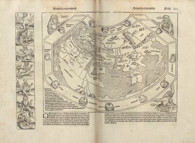
Liber chronicarum, 1493
This book, hugely popular when it was first published, represents an illustrated history of the world. The map is based on a second century Ptolemy map and depicts the continents of Europe, Asia, and Africa. Each continent is affiliated with the son of Noah who was believed to have settled there after the flood. There is no depiction of the Americas on the map because its printing coincided with the return of Christopher Columbus’ first expedition. Like all the other illustrations in the book, this map was produced using the woodcut technique. Woodcuts are a relief process whereby the design is carved out of a wooden board, which results in a relatively crude outline that provides little detail.