North Bay
2 items
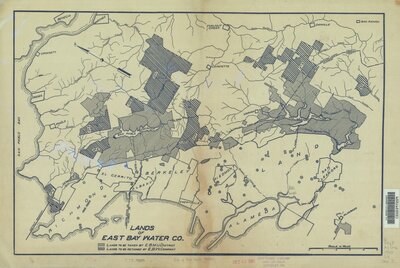
- Description:
- Publisher not identified. Shows "Lands to be taken by E.B.M.U. District," and "Lands to be retained by E.B.W. Company."
Oriented with north toward upper left.
Blue line print.
- Attribution:
- UC Berkeley Library
- Date:
- 1920

- Description:
- Published by Britton & Rey from San Francisco. This map is double the size of the usual tide land maps and shows the shore of the east bay from Oakland north to Point San Pablo. Cadastral map showing drainage, township and section lines, land ownership, ranchos, lot numbers, railroads, etc. Hand colored (for uncolored copy see our 3972). Printed on 2 sheets, mounted together.
- Attribution:
- David Rumsey Historical Map Collection
- Date:
- 1872