Search Constraints
Search Results
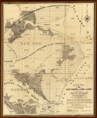
- Description:
- The author is G.F. Allardt and the attributed author is the California Board of Tide Land Commissioner. The publisher is G.T. Brown & Co. Lith. located in San Francisco. Sale maps of state tide lands in Marin are more scarce than those of San Francisco or the East Bay. Shows San Rafael and San Quentin and the railroad connecting them. Covers area from Corte Madera Canal (south of San Quentin) to Gallinas Canal. Grafton T. Brown was the first African American lithographer in San Francisco. Relief shown by hachures. Shows drainage, township and section lines, lot numbers, land ownership, ranchos, etc.
- Attribution:
- David Rumsey Historical Map Collection
- Date:
- 1871
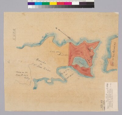
- Description:
- From: U.S. District Court. California, Northern District. Land case 429 ND, page 418; land case map D-928 (Bancroft Library). José Y. Limantour, clmt.Oriented with north toward upper right corner.Pen-and-ink and watercolor.4362 C682"5. L.D.K."On label attached to map: Islands of Farrallones, Alcatraz & Yerba Buena, 1 sq. league in Marin County.
- Attribution:
- UC Berkeley, Bancroft Library
- Date:
- 184-?
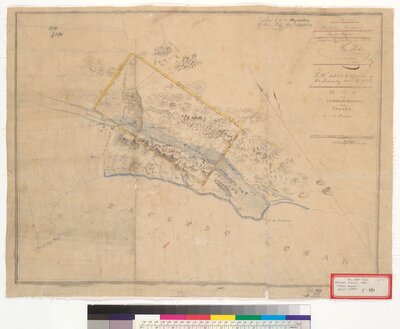
- Description:
- The author is J.H. Forsler and the creator is the United States District Court for the Northern District of California. "No. 525 ... Filed in Office Dec. 4, 1854."Oriented with north toward upper left corner.From: U.S. District Court. California, Northern District. Land case 418 ND, page 256; land case map E-894 (Bancroft Library). Bethuel Phelps, clmt.Pen-and-ink and watercolors.4362 T615Relief shown by hachures.
- Attribution:
- UC Berkeley, Bancroft Library
- Date:
- 1854
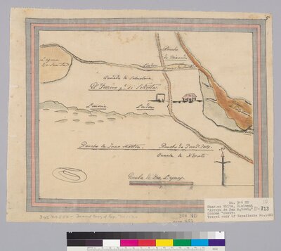
- Description:
- The creator is the United States District Court for the Northern District of California. Pen-and-ink and watercolors. Relief shown pictorially. On label attached to map: Traced copy of Expediente No. 10 ND.Rancho is in Marin County, not Sonoma County as stated on label. From: U.S. District Court. California, Northern District. Land case 346 ND, page 845; land case map D-713 (Bancroft Library).
- Attribution:
- UC Berkeley, Bancroft Library
- Date:
- 184-?
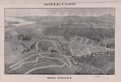
- Description:
- The creator is Commercial Art Co. T.G. Parker Company. On verso: bird's eye view, signed "Spofford" and credited to Commercial Art Co., 519 Mission St., S[an] F[rancisco].
Tract boundaries: Carmelita Ave., Erata, the Carmelita Boyle estate, county road (now E. Blithedale).
Shows block and lot numbers, lot sizes.
Includes text.
- Attribution:
- UC Berkeley Library
- Date:
- 1906
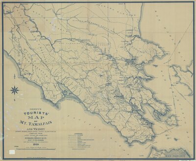
- Description:
- The publisher is Edward Denny & Co. from San Francisco. Blue line print.
Relief shown by spot heights.
- Attribution:
- San Francisco, Edward Denny & Co.
- Date:
- 1910
- Description:
- The authors are Ringgold, Cadwalader and Fred D. Stuart. The publisher is Jno. T. Towers from Washington. 1st Marin county map - Vogdes. Shows Mexican Land Grants, School Districts, land ownership, towns, topography, roads, railroads, etc. With black top and bottom rollers. Full color by township. Relief shown by hachures. Population and personal property values statistics. Town of San Rafael inset scale 1:7,200. Town of Nicasio inset scale 1:2,400. Mounted on muslin; some portions stained; some portion of Marin Headlands area (Golden Gate) missing.
- Attribution:
- David Rumsey Historical Map Collection
- Date:
- 1852
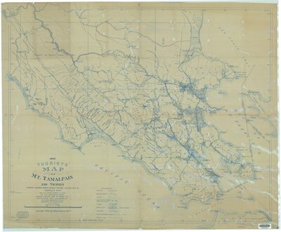
- Description:
- Created by P.C. Knapp, A.H. Sanborn, and
Edward Denny & Co. Blue line print. Relief shown by spot heights.
- Attribution:
- UC Berkeley Library
- Date:
- 1902
- Description:
- The creator is A.H. Sanborn. Published by Ad Book Press in San Francisco.
- Attribution:
- UC Berkeley Library
- Date:
- 1898
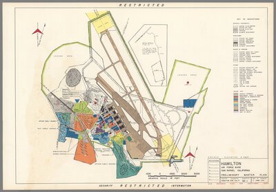
- Description:
- The author is the United States Air Force from Washington, D.C. Color Air Force Base plan. In lower panel: "Restricted security information". Includes key to indication and colored key to Air Force base facilities. Relief shown by contours and spot heights. On verso: Vicinity map.
- Attribution:
- David Rumsey Historical Map Collection
- Date:
- 1951